- The State of the Gulf of Mexico (July 2008)
- The State of Lakes (July 2007)
- The State of Wetlands (July 2006)
- The State of Springs (July 2005)
- The State of Rivers (July 2004)
- The State of Bays (July 2003)
- The State of Water (July 2002)

The State of Water in the Big Bend
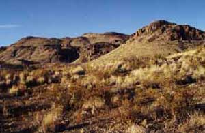
Scarce water supplies sustain a rugged, yet fragile ecosystem in the Big Bend, also known as the Trans Pecos.
Major Water Challenge: Water shortages due to combined effects of long term drought and increasing competition with Mexico and other states for a limited supply.
Water Resource Problems: Increasing salinity in both groundwater and surface water due to decreased water supply. Population is expected to double by 2050.
The Big Bend area, also known as the Trans Pecos, occupies the extreme western part of the state eastward to the Pecos River. This is a region of diverse habitats and vegetation, varying from desert valleys and plateaus to wooded mountain slopes. Elevations range from 1,850 feet to more than 8,749 feet at Guadalupe Peak. Even the mountain ranges vary greatly in the environments they offer for plant and animal life; some are characterized by volcanic rocks, others by limestone.
Over most of the area, average annual rainfall is less than 12 inches but varies greatly from year to year and from lower to higher elevations. July and August are usually the higher rainfall months.
West Texas streams are part of a very fragile ecosystem, dependent upon a scarce water supply, often fed by springs. As in other parts of the state, these streams provide a variety of habitats, from shallow, swift-flowing areas to deeper, slow-moving pools supporting a variety of fish, reptiles, amphibians, insets and mammals. Because water is scarce here, the riparian areas (banks of a river, stream or lake) team with wildlife.
Cienegas are small isolated spring-fed wetlands that occur in desert areas of the Trans-Pecos. In some areas, mountain springs create small wetlands in higher elevations. Cienegas and mountain springs provide enough water for plants and animals that don’t normally survive in the desert, giving west Texas a much greater variety of species than most people would think.
Human activity can affect these streams and cienegas. Overuse of water from aquifers can lower the water table to the point that springs stop flowing and springs dry up. Groundwater can carry pollutants to these streams if care is not taken to contain or dispose of of pollutants properly. The type of vegetation allowed to grow along stream banks can affect the amount of available water (a single salt cedar can draw 30 gallons of water each day). Destroying all vegetation or disturbing stream beds will reduce cover and food for fish.
Mountain outwash materials have formed the soils of the Trans Pecos. Surface textures and profile characteristics are varied, however. Due to the diversity of soils and elevations, many vegetation types exist in the region. The principal plant communities are creosote-tarbush desert scrub, desert grassland, yucca and juniper savannahs, and montane forests of pinon pine and oak.
The various subregions reflect the diversity of the Trans Pecos. The Sand Hills area consists of shin oak and mesquite on wind-blown dunes. Flat-topped mesas and plateaus are intersected by steep-walled canyons and dry washes that comprise the Stockton Plateau. Soils with high salt content and gypsum dunes are typical of the Salt Basin area. The Desert Scrub subregion is an area of low rainfall and rapid drainage. Creosote bush flats with yucca, lechuguilla, and various small-leafed plants are common. The Desert Grassland area occurs in the central part of the region and is characterized by deeper soils with high clay content. Finally, the Mountain Ranges have higher rainfall and woody vegetation such as junipers, oaks, pinon pine, ponderosa pine, and Douglas fir.
Ranching is the primary industry in the Trans Pecos region.
Water Supply and Demand
Supply
Major River: Rio Grande
Major Aquifer: Hueco-Mesilla Bolson
Use & Demand
- 60% demand met through surface water.
- 75% demand is for irrigation, 22% for municipal needs.
- By 2050, the population of the area is expected to double. The demand for water is expected to change to 50% for irrigation, and 44% for municipal needs. (Source: Texas Center for Policy Studies. Texas Environmental Almanac (Austin: U.T. Press, 2002), 22.)
Major Cities - Rainfall / Elevation
Regional Average Rainfall: 8-20 inches per year
Regional Average Net Evaporation rate: 52-68 inches
Data source: National Climate Datat Center, U.S. Dept of Commerce.
Balmorhea - 14.19 in. / 3,220 ft.
Castolon (Big Bend National Park) - 9.80 in. / 2,169 ft.
Chisos Basin (Big Bend National Park) - 19.17 in. / 5,300 ft.
El Paso - 9.43 in. / 3,918 ft.
Fort Davis - 15.86 in. / 4,880 ft.
Fort Stockton - 14.06 in. / 3,000 ft.
Marathon - 14.51 in. / 4,055 ft.
Marfa - 15.79 in. / 4,760 ft.
Pecos - 11.61 in. / 2,610 ft.
Presidio - 10.76 in. / 2,560 ft.