- Trans Pecos
- High Plains/Panhandle
- Cross Timbers
- Hill Country
- Post Oak Savannah
- Pineywoods
- Oak Prairie
- South Texas Plains
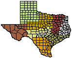
Wildlife Division District Map
Panhandle Wildlife Management
Physiographic Geographic Regions
Rolling Red Plains
Location and topography

Blue quail.
The Rolling Red Plains extends north from the Edwards Plateau in Texas to western Oklahoma. Landscape is flat to rolling, with natural vegetation of mixed-grass plains, shortgrass high plains, shinnery oak grasslands, and mesquite grasslands. Mixed prairie represents the transition zone between tall-grass prairie and other plant associations in the western part of this physiographic area. Grasses and forbs are dominant vegetation. Shinnery oak grasslands occur in broad rolling topographic relief of the western and northern parts of the area. Oak mottes (clumps) occur throughout broad expanses of tall, mixed, or short grasses. Mesquite-grassland is perhaps the most extensive vegetation community; this association typically occurs on flat gently rolling topography with an open canopy of short mesquite trees with an understory of prickly pear and thorny shrubs. These natural communities were maintained by numerous harsh weather events, such as sever winter weather, cycles of hot temperatures, drought, and fire.
Major conservation issues
Much of the Rolling Red Plains has been altered by agriculture and ranching. Remaining natural plant communities are affected by fragmentation, direct loss due to crops, pasture, and overgrazing. Efforts to conserve wildlife and habitat diversity will require strong cooperation with private landowners to provide increased incentives for management of riparian zones and oak motte restoration, and increased management of natural grassland systems.
Pecos & Staked Plains
Location and physiography
The Pecos & Staked Plains cover the western panhandle of Texas, west end of the panhandle of Oklahoma, and extensive areas in eastern New Mexico. These high and dry plains are covered with shortgrass prairie dominated by grama and buffalo grasses. There also are extensive areas of shinnery oak with short to midgrass prairie and low shrubs. This area grades from tall-grass in the east to scrub savanna in the southern Trans-Pecos, and more chaparral and pinyon-juniper in the Mesa and Plains areas to the west. The northern border of Oklahoma is as an arbitrary northern limit.
Major conservation issues and recommendations
Much of this area is used for ranching, it remains in relatively good condition, and supports numerous populations of native wildlife. However, conversion to agriculture with use of circle-pivot irrigation is taking its toll on wildife habitat, particularly in the east. A careful grazing regime with rest and rotation that allows moderate fuel buildup for occasional fires provides the best long-term benefit to both the rancher and to wildlife. For example, black-tailed prairie dog towns, which have greatly diminished, provide conditions preferred by many priority birds. Shrubland components used by some of the highest priority birds, including Lesser Prairie-Chicken, should not be eliminated through herbicide treatment. Management of Lesser Prairie-Chicken habitat needs to be aggressive to halt decline of this rare bird. Native rangeland surrounding lek sites should be retained and grazing managed to create conditions required by the species. Ephemeral playas and non-riparian wetlands are unique features of this physiographic area in which grazing and water management can benefit many birds. Termination of residual pesticide run-off, dumping of oil and gas waste by-products and disruption of clay bottoms for creation of more permanent water sources will maintain playa conditions needed by many species of wildlife.
Biological Distinctiveness
The Western Short Grasslands are among the most biologically diverse ecoregions in the United States and Canada. Part of this richness can be explained by the close proximity of this ecoregion to the subtropics. This ecoregion once supported one of the most impressive migrations of large ungulate species anywhere in the world - the American bison migration. Today, bison no longer migrate, but bison ranching is becoming increasingly popular. Western Short Grasslands also contain the fastest declining bird populations on the continent. These species are declining faster than many neotropical migratory birds, whose plight receives much more attention.
Conservation Status
Habitat Loss & Degradation
Much of the Western Short Grassland Ecoregion has been adversely affected by efforts to develop dryland agriculture. Nearly all the region is in farms and ranches. Cropland varies between 30% and 60% across the ecoregion, with grazing lands occupying the remainder. Areas in the Texas Northern Plains (southern Western Short Grass Ecological Region) have been invaded by mesquite and thorny shrubs, forming a savanna or shrubland with a shortgrass prairie understory. In the southern portion of the High Plains overgrazing and poisoning of black-tailed prairie dog colonies has allowed the spread of woody shrubs and trees, and the near permanent conversion of plains grassland to desert scrublands.
Remaining Blocks of Intact Habitat
The only remaining "intact" blocks of shortgrass prairie occur within national grasslands and wildlife refuges. In Texas these are:
- Rita Blanca and Kiowa national grasslands along the northeast border of Texas with New Mexico and Oklahoma
- Black Kettle National Grassland at the eastern boundary of the Texas Panhandle and western Oklahoma
- Buffalo Lake National Wildlife Refuge in the central Texas Panhandle
Other significant areas of intact native habitat are Palo Duro Canyon and Cap Rock Canyon in the central Texas Panhandle.
Degree of Protection
Although there is considerable rangland and grassland worthy of conservation, few sites are formally protected. National grasslands have considerable potential for conservation of biological diversity, but grazing on these units by domestic livestock must be modified.
Types of Threats
The major threat to the ecoregion is fragmentation of native habitats, conversion to agriculture, and overgrazing. New technologies (4-wheel-drive tractors, "precision farming," herbicides, and irrigation) make farming more productive in areas that were preciously difficult to cultivate. Central-pivot irrigation has also caused conversion. Fire increases forage production, makes grasses more palatable, eliminates undesirable annuals, and suppresses invasion of mesquite, juniper, cedar, and cacti; thus fire suppression constitutes another threat. Although overgrazing tends to be less of a threat in the region, because of the abundance of grazing-tolerant plant species, overgrazing by domestic stock, particularly along riparian (perennial/annual streams), wetland, and playa lake ecosystems is a serious problem that degrades habitat and biological diversity.
Regional Goals for Conservation of Natural Resources
- Make national grassland management more sensitive and responsive to state needs for conservation of regional biological diversity.
- Work with private landowners and conservation associations to maintain native rangeland systems, and riparian, wetland, and playa lake ecosystems.
- Encourage use of rotational grazing to mimic natural grazing regimes.
- Continue to promote the Technical Guidance Program by strengthening the working relationship with individual private landowners and cooperatives.
- Continue to fund and promote the Landowner Incentive Program and strengthen the working relationship with individual landowners and cooperatives at the city and county levels.
- Promote and facilitate partnering and a functional relationships with other federal and private resource agencies working in the region.
- Restore and enlarge the best remaining representative areas for biological diversity.
You can get more information by contacting your local biologist. To find your local biologist, locate your county on the Wildlife District Map.